Last official estimated population of Washington County was 531,345 (year 2014)[1]. This was 0.167% of total US population and 13.2% of total Oregon state population. Area of Washington County is 726.7 mi² (=1882.1 km²), in this year population density was 731.20 p/mi². If population growth rate would be same as in period 2010-2014 (+0.08%/yr), Washington County population in 2026 would be 536,280 [0].
Historical population of Washington County for period 1850-2014 [1] , [2] , [3]:
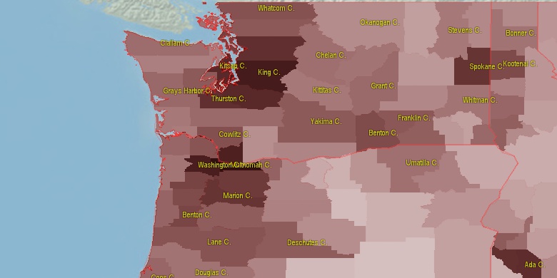
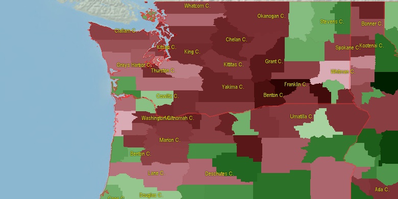
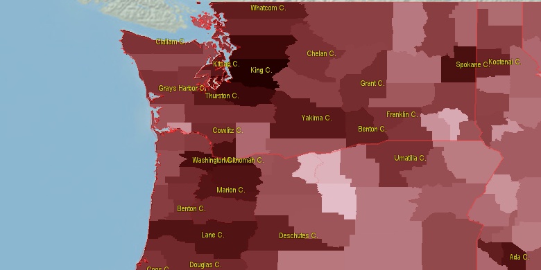
Estimated population for 2014[1]. Population density is in p./sq.mi [4]. Changes are for period 2010-2015. Value is %/year. Boundary lines are approx. 2012 [5]. Click on flag to hide it.
Population • Density • Changes • Legends • Position

[1850-1860] +0.55 %/yr
[1860-1870] +4.28 %/yr
[1870-1880] +5.21 %/yr
[1880-1890] +5.39 %/yr
[1890-1900] +1.91 %/yr
[1900-1910] +4.05 %/yr
[1910-1920] +2.05 %/yr
[1920-1930] +1.39 %/yr
[1930-1940] +2.62 %/yr
[1940-1950] +4.57 %/yr
[1950-1960] +4.18 %/yr
[1960-1970] +5.52 %/yr
[1970-1980] +4.52 %/yr
[1980-1990] +2.4 %/yr
[1990-2000] +3.64 %/yr
[2000-2005] +1.97 %/yr
[2005-2010] +1.54 %/yr
[2010-2014] +0.08 %/yr
Looking for settlements in Washington County? Visit this page: Settlements in Washington County, OR
Population of Washington County by age groups male (M) and female (F)[1b]
| Age Gr. | (M) | (F) | Total |
| 0 to 4 | 18873 | 18101 | 36,974 |
| 5 to 9 | 19749 | 18926 | 38,675 |
| 10 to 14 | 19829 | 18866 | 38,695 |
| 15 to 19 | 18111 | 17030 | 35,141 |
| 20 to 24 | 17076 | 17200 | 34,276 |
| 25 to 29 | 20451 | 20372 | 40,823 |
| 30 to 34 | 22476 | 22325 | 44,801 |
| 35 to 39 | 21261 | 21188 | 42,449 |
| 40 to 44 | 21251 | 20914 | 42,165 |
| 45 to 49 | 19456 | 19181 | 38,637 |
| 50 to 54 | 18664 | 19134 | 37,798 |
| 55 to 59 | 17271 | 18170 | 35,441 |
| 60 to 64 | 14244 | 16114 | 30,358 |
| 65 to 69 | 10973 | 12872 | 23,845 |
| 70 to 74 | 7080 | 8608 | 15,688 |
| 75 to 79 | 4434 | 5887 | 10,321 |
| 80 to 84 | 3043 | 4353 | 7,396 |
| 85+ | 3182 | 6333 | 9,515 |
Washington County resident population estimates by Sex, Race, and Hispanic Origin[1b]. For full list of abbrevations see: population.us/about page.
| Race | Male | Female | Total |
| WAC | 238728 | 245417 | 484,145 |
| NH | 230592 | 240735 | 471,327 |
| WA | 228133 | 234652 | 462,785 |
| NHWAC | 195609 | 204189 | 399,798 |
| NHWA | 186695 | 195173 | 381,868 |
| H | 46832 | 44839 | 91,671 |
| HWAC | 43119 | 41228 | 84,347 |
| HWA | 41438 | 39479 | 80,917 |
| AAC | 32616 | 35356 | 67,972 |
| NHAAC | 31266 | 34007 | 65,273 |
| AA | 26532 | 29189 | 55,721 |
| NHAA | 25922 | 28605 | 54,527 |
| TOM | 11284 | 11501 | 22,785 |
| NHTOM | 9505 | 9635 | 19,140 |
| BAC | 9589 | 8351 | 17,940 |
| NHBAC | 8187 | 6886 | 15,073 |
| IAC | 6248 | 6422 | 12,670 |
| BA | 6748 | 5550 | 12,298 |
| NHBA | 5849 | 4607 | 10,456 |
| NHIAC | 3569 | 3797 | 7,366 |
| IA | 3251 | 3223 | 6,474 |
| NAC | 2909 | 3021 | 5,930 |
| HIAC | 2679 | 2625 | 5,304 |
| NHNAC | 2479 | 2600 | 5,079 |
| HIA | 1894 | 1781 | 3,675 |
| HTOM | 1779 | 1866 | 3,645 |
| NA | 1476 | 1459 | 2,935 |
| HBAC | 1402 | 1465 | 2,867 |
| NHIA | 1357 | 1442 | 2,799 |
| HAAC | 1350 | 1349 | 2,699 |
| NHNA | 1264 | 1273 | 2,537 |
| HBA | 899 | 943 | 1,842 |
| HAA | 610 | 584 | 1,194 |
| HNAC | 430 | 421 | 851 |
| HNA | 212 | 186 | 398 |
• Multnomah County population
32.9 mi,  90°
90°
• Clark County
33.2 mi,  62°
62°
• Clackamas County
51.5 mi,  121°
121°
• Marion County
51.7 mi,  150°
150°
• Cowlitz County
48.5 mi,  25°
25°
• Yamhill County
23.6 mi,  206°
206°
• Polk County
47.4 mi,  197°
197°
• Columbia County
26.8 mi,  1°
1°
• Clatsop County
43.8 mi,  318°
318°
• Tillamook County
32.7 mi,  258°
258°
[0] Calculated by population.us from last known population growth rate, not official data.
[1] County population - 2014, archived from the original, retrieved 02/23/2016
[1b] Annual County Resident Population Estimates by Age, Sex, Race, and Hispanic Origin, (used only data for 2014) archived from the original, retrieved 02/23/2016
[2] County population - 2000-2010, archived from the original, retrieved 02/23/2016
[3] Population of States and Counties of the United States: 1790 to 1992, PDF, 15 Mb, census.gov, retrieved 02/23/2016
[4] County area, latitude longitude data, retrieved 02/23/2016
[5] County boundaries, CSV files on boundaries.us, retrived 03/18/2016
Page generated in 0.006 seconds© 2016 population.us | Terms of use | Contact